


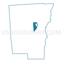
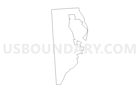
Voting District 120002, Chenango County, New York
About
Outline

Summary
| Unique Area Identifier | 626017 |
| Name | Voting District 120002 |
| County | Chenango County |
| State | New York |
| Area (square miles) | 10.62 |
| Land Area (square miles) | 10.62 |
| Water Area (square miles) | 0.00 |
| % of Land Area | 100.00 |
| % of Water Area | 0.00 |
| Latitude of the Internal Point | 42.51812450 |
| Longtitude of the Internal Point | -75.54148980 |
Maps


Graphs
Select a template below for downloading or customizing gragh for Voting District 120002, Chenango County, New York


Neighbors
Neighoring Voting District (by Name) Neighboring Voting District on the Map
- Voting District 110001, Chenango County, NY
- Voting District 120001, Chenango County, NY
- Voting District 120003, Chenango County, NY
- Voting District 130101, Chenango County, NY
- Voting District 130201, Chenango County, NY
- Voting District 130301, Chenango County, NY
- Voting District 130401, Chenango County, NY
- Voting District 130501, Chenango County, NY
- Voting District 150003, Chenango County, NY
- Voting District 180001, Chenango County, NY
- Voting District 190001, Chenango County, NY
Top 10 Neighboring County Subdivision (by Population) Neighboring County Subdivision on the Map
- Norwich city, Chenango County, NY (7,190)
- Norwich town, Chenango County, NY (3,998)
- Oxford town, Chenango County, NY (3,901)
- Plymouth town, Chenango County, NY (1,804)
- North Norwich town, Chenango County, NY (1,783)
- Preston town, Chenango County, NY (1,044)
Top 10 Neighboring Place (by Population) Neighboring Place on the Map
Top 10 Neighboring Unified School District (by Population) Neighboring Unified School District on the Map
- Norwich City School District, NY (13,368)
- Sherburne-Earlville Central School District, NY (8,599)
- Oxford Academy and Central School District, NY (5,359)
Top 10 Neighboring State Legislative District Lower Chamber (by Population) Neighboring State Legislative District Lower Chamber on the Map
Top 10 Neighboring State Legislative District Upper Chamber (by Population) Neighboring State Legislative District Upper Chamber on the Map
Top 10 Neighboring 111th Congressional District (by Population) Neighboring 111th Congressional District on the Map
Top 10 Neighboring Census Tract (by Population) Neighboring Census Tract on the Map
- Census Tract 9705, Chenango County, NY (5,683)
- Census Tract 9706.01, Chenango County, NY (4,225)
- Census Tract 9703, Chenango County, NY (4,067)
- Census Tract 9706.02, Chenango County, NY (3,948)
- Census Tract 9704, Chenango County, NY (3,123)